- Brightmoor Neighborhood, City of Detroit, Michigan
- Central Neighborhood, City of Detroit, Michigan
- Chadsey-Condon Neighborhood, City of Detroit, Michigan
- Cody-Rouge Neighborhood, City of Detroit, Michigan
- Osborne Neighborhood, City of Detroit, Michigan
- Vernor-Boynton, City of Detroit, Michigan
Michigan Census Map Descriptions
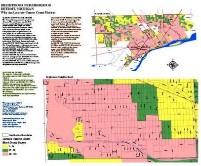 |
Brightmoor Neighborhood, City of Detroit, Michigan
This map uses Census Bureau data at the Block Group level to show the “hard to count” areas in the Brightmoor Neighborhood, City Detroit, Michigan. Hard to count areas are where it is more likely that there will be a census undercount in 2010. An “undercount” means less federal grant funds for the cities and counties, as well as the state. A census undercount can undermine the creation of fair political districts. It can also result in the allocation of fewer seats in the US Congress than the state would have if there is a full and accurate count of all persons. |
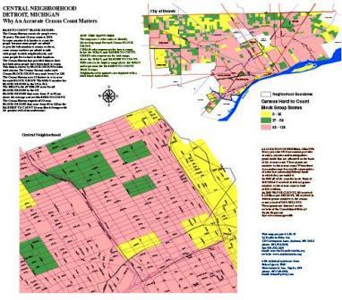 |
Central Neighborhood, City of Detroit, Michigan
This map uses Census Bureau data at the Block Group level to show the “hard to count” areas in the Central Neighborhood, City Detroit, Michigan. Hard to count areas are where it is more likely that there will be a census undercount in 2010. An “undercount” means less federal grant funds for the cities and counties, as well as the state. A census undercount can undermine the creation of fair political districts. It can also result in the allocation of fewer seats in the US Congress than the state would have if there is a full and accurate count of all persons. |
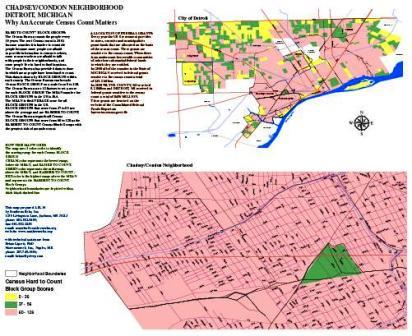 |
Chadsey-Condon Neighborhood, City of Detroit, Michigan
This map uses Census Bureau data at the Block Group level to show the “hard to count” areas in the Chadsey-Condon Neighborhood, City Detroit, Michigan. Hard to count areas are where it is more likely that there will be a census undercount in 2010. An “undercount” means less federal grant funds for the cities and counties, as well as the state. A census undercount can undermine the creation of fair political districts. It can also result in the allocation of fewer seats in the US Congress than the state would have if there is a full and accurate count of all persons. |
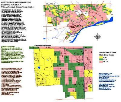 |
Cody-Rouge Neighborhood, City of Detroit, Michigan
This map uses Census Bureau data at the Block Group level to show the “hard to count” areas in the Cody-Rouge Neighborhood, City Detroit, Michigan. Hard to count areas are where it is more likely that there will be a census undercount in 2010. An “undercount” means less federal grant funds for the cities and counties, as well as the state. A census undercount can undermine the creation of fair political districts. It can also result in the allocation of fewer seats in the US Congress than the state would have if there is a full and accurate count of all persons. |
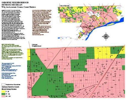 |
Osborne Neighborhood, City of Detroit, Michigan
This map uses Census Bureau data at the Block Group level to show the “hard to count” areas in the Osbourne Neighborhood, City Detroit, Michigan. Hard to count areas are where it is more likely that there will be a census undercount in 2010. An “undercount” means less federal grant funds for the cities and counties, as well as the state. A census undercount can undermine the creation of fair political districts. It can also result in the allocation of fewer seats in the US Congress than the state would have if there is a full and accurate count of all persons. |
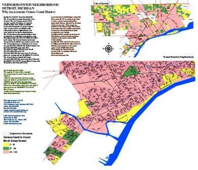 |
Vernor-Boynton Neighborhood, City of Detroit, Michigan
This map uses Census Bureau data at the Block Group level to show the “hard to count” areas in the Vernor-Boynton Neighborhood, City Detroit, Michigan. Hard to count areas are where it is more likely that there will be a census undercount in 2010. An “undercount” means less federal grant funds for the cities and counties, as well as the state. A census undercount can undermine the creation of fair political districts. It can also result in the allocation of fewer seats in the US Congress than the state would have if there is a full and accurate count of all persons. |

